Water and Human Settlements

Initiative

Currently half the global population lives in cities. By 2050, nearly 70% of the world will be urbanites. As the urban population continues to rise, infrastructure ages, and water-related disasters (flooding, hurricanes, landslides, storm-surges, waterborne diseases, drought) become more frequent, cities face a unique set of water challenges that require creative, impactful, and contextual solutions. The CAPPA Water and Human Settlements Initiative puts to work the special combination of design, planning, and policy that CAPPA offers to tackle these problems with innovation and scholarly rigor.

Projects and Programs

Resilient Watershed Urbanism will speculate on methods to form a new way for cities to utilize nature for the combined benefit of humans, landscape, climate and the current wildlife.

TEAM MEMBERS

  • Kevin W. Sloan: Professor in Practice, Landscape Architecture
  • Nick Fang: Assistant Professor, Department of Civil Engineering
  • Michael Zaretsky: Associate Professor, UTA Department of Civil Engineering

TITLE OF PROJECT

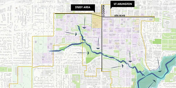
Assessing the Value of Resilient Watershed Urbanism (RWU) Trinity River Marsh

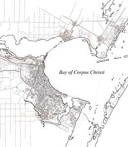
This research will extend the work and discoveries gained through twenty-plus years of planning, landscape and architectural practice, publication, and research in DFW and the surrounding region. The rivers, reservoirs, creeks, and ravines, of the vast watershed network that traverses the seven million-acre Metroplex, are a catalyst for new urban formations along natural corridor edges.

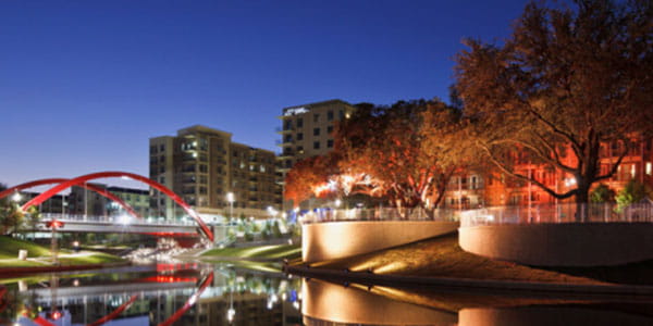
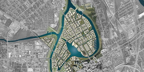
Recently, the formation of dense new urban enclaves along the nature of the watershed network is unguided by larger planning policies. This new development has not built upon the success of communities surrounding White Rock Lake and the Turtle Creek corridor. Both examples leveraged what were otherwise ordinary natural features into cultural and environmental assets of extraordinary value. Kevin Sloan, professor of practice in architecture, is the principal investigator of the research proposal and has identified this process through prior research, lectures, journal articles, and the unprecedented patterns it could construct with nature as “The North Texas Branch Water Network.”

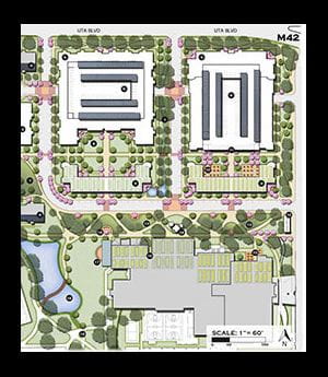
The research will begin with the selection of one water branch within the overall network. A sponsored design studio, scheduled for the Fall 2019 will focus on the exploration of an urban design code that could suffice as rules or a “game” that could more deliberately guide the formation of urban enclaves within these water networks. The studio is imagined as a cross disciplinary team of architects, landscape architects and civil engineers and co-taught by the three research principals, including Michael Zaretsky, associate professor of civil engineering.

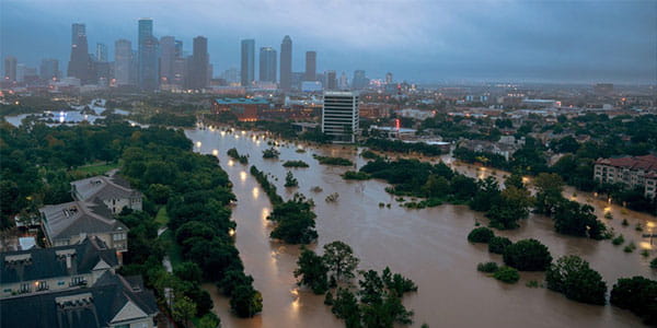
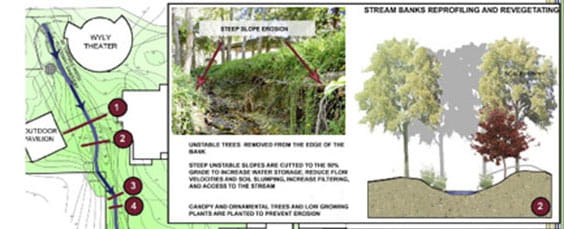
Instrumental to the research is the simultaneous assessment of methods to predict and manage the chronic and unpredictable flooding of the watershed network. Dr. Nick Fang, assistant professor in civil engineering, has research and development of real time flood modeling that will be applied to anticipate the effects of climate change and flooding on the selected research corridor.

Another aspect included in this water research is the concept of ReWILDING, a practice of designing green space to attract wildlife and reframe cities. What distinguishes ReWILDING is creating cities that enable wildlife to appropriately inhabit it, making it a condition where wildlife and our suburban society coexist. There will be an environmental assessment of the selected branch water corridor for it’s potential for ReWILDING.

Resilient Watershed Urbanism will speculate on methods to form a new way for cities to utilize nature for the combined benefit of humans, landscape, climate and the current wildlife.

night time shot of a city with a bridge over the water

Research funded by Center for Transportation Equity, Decisions and Dollars (CTEDD)

  • Diane Jones Allen, Associate Professor of Landscape Architecture
  • Arne Winguth, Associate Professor in Oceanography
  • Graduate Research Assistants Niveditha Das Gangadhar, Josh Joshua A.Pulcinella, Gennadii Prykhodko

ABOUT THE PROJECT

This research under takes a vulnerability assessment will be made by combining storm surge and extreme rainfall projections with the Transit Deserts method that assesses geographic vulnerability, in regards to access to employment and other services that impact quality of life, and transit equity and access.

Thousands of residents had no means to evacuate from flooded areas in New Orleans during Hurricane Katrina or in Houston during Hurricane Harvey, due to the lack of affordable and available transportation. Thus there is an urgent need to evaluate the vulnerability of transportation infrastructure and mass transit in relationship to climate change and extreme weather.

The project tasks include preliminary compilation of a transportation risk assessment map for the Houston metropolitan area by synthesizing the Transit Desert method (i.e.transportation, mass transit maps, transportation availability) with storm surge maps (including projected sea level rise), and the 100/500-year flood zone.

Map source from: CartoGIS Services, College of Asia and the Pacific, The Australian National University

TEAM MEMBERS

TITLE OF PROJECT

Integrated Urban Flood Management

Shortages of drinking water, food, and housing; health risks from water-borne diseases; loss of life; and severe impacts on livelihoods – all can stem from a common cause: urban flooding. An interdisciplinary team of researchers from UTA, Cotton University, and Shiv Nader University (both in India) will pool their expertise to address this critical urban issue, via a $20,000 grant from CAPPA’s Water and Human Settlement Program.

The project’s goal is to build integrated, sustainable solutions to the problem of urban flooding, by drawing on multiple perspectives (public policy and administration, engineering, and geography), as well as input from local stakeholders. Researchers will examine the global issue of urban flooding through the lens of a particular case study, Guwahati, India.

Guwahati is the capital city of the state of Assam, and is the largest city with commercial, industrial, and educational benefits in northeastern India. The river Brahmaputra flows through the city and during the monsoon season, it flows above danger level, resulting in flooding of the low-lying areas of the city. The city has had a 128% population growth in the last seven years.

The causes of flooding in Guwahati include rapid population growth, rampant construction in floodplain areas, encroachment into floodplains by migrants to the city, large-scale deforestation, and lack of integrated water management policies and effective infrastructure planning. Researchers thus expect aspects of the multi-disciplinary solutions that emerge to be broadly applicable.

Associate Professor of Public Affairs, Karabi Bezboruah and Associate Professor of Civil Engineering, Melanie Sattler, will partner with researchers from India. They will collect information on best practices for integrated flood management and conduct focus groups. The groups will be with Guwahati government officials and community-based organizations to identify grassroots strategies for avoiding and mitigating flooding impacts. "We're so excited to have this opportunity to collaborate internationally to address a very critical issue," said Sattler. Model regulations for limiting floodplain development and examples of ways to identify flood-prone areas will be provided.

Lastly, the team will share the innovative water management policies and infrastructure planning practices they have discovered, via training workshops at Cotton University in India. Government officials, NGO executives, engineers, architects and real estate developers will be invited to attend the workshops.

“It’s a great opportunity to collaborate with eminent international researchers on the topic of urban flooding and to come up with grassroots solutions that will have significant social impact,” said Bezboruah “This grant provides the much-needed support for such interdisciplinary global initiatives.”

flood-management-india

North Side's Relationship with the Trinity River and Marine Creek

TEAM MEMBERS

  • Dennis Chiessa, Assistant Professor, School of Architecture
  • Rod Hissong, Associate Professor, Public Affairs
  • Taner Ozdil, Associate Professor, Landscape Architecture
  • Nazanin Ghaffari, Instructor of Planning, Planning

TITLE OF THE PROJECT

North of the Island

For the past decades, neoliberalism has become the target of growing interest not only in political and economic debates but also in the social sciences, and urban studies. Scholars argue that in neoliberal cities, urban elites and private agencies play a fundamental role in the decision-making process; thus cities are run in business styles with entrepreneurial discourses (Harvey, 1989; Harvey, 2008). In view of this, policies are set to address capital interest instead of fulfilling citizens' needs, and municipalities role have shifted from the managers of collective goods to economic promoters within the free market logic and neoliberal philosophy, where public-private partnerships are a promoted form of governance and private sectors play an increasingly active role in the decision-making process.

Fort Worth, the 15th-largest city in the United States, the fifth-largest city in Texas and the fifthon the Forbes’ annual (2018) list of America’s fastest-growing cities, may be among the best examples of the traditional neo-liberal cities. Conversely, preservation of Western heritage, quality and ethnic diversity of cultural life, arts, neighborhood vitality, and preservation of historic buildings and districts are the principal values identified by Fort Worth residents to define and guide the city's future in their recent comprehensive plan (2018). Panther Island, the flagship project of Trinity River Vision Authority [TRVA], is promoted as a solution for “smart, sustainable redevelopment of our city’s core” and a transformation of a neglected industrial sector “into a vibrant riverfront neighborhood with green spaces bustling with activity and opportunities for living, employment and education.” The project extends into Marine Creek in the stockyards and Gateway Park in Riverside, both largely Hispanic neighborhoods. Panther Island will bring 20,000 people to live and work in it. Public funds are being used to provide flood protection and sustainable infrastructure improvements, the TRVA claims that there is a need for updating flood protection in the city’s near north side, along with the community’s desire for an urban waterfront and this has led them to develop the Panther Island project.

The Stockyards situated directly on top of Marine Creek, one of the largest tributaries of the Trinity River and part of the TRVA project, is also undergoing a major redevelopment. The Stockyards, once the economic engine of the city, is a major tourist attraction drawing three million visitors annually. Conversely, some of the locals have described the Stockyards as the downtown of the North Side. Yet, the economic impact of the Stockyards on the North Side is not immediately evident. Particularly when looking at socio-economic realities of the area. The North Side has a strong Mexican-American identity. It is located north of the river from Downtown and West 7th area. The river has served as a physical barrier between the NS and the rest of the city, this is very clear when looking at a figure ground of the city, which may have resulted in social, cultural, and economic isolation. The railroad and the stockyards were also undesirable as they brought unpleasant smells, noise and industrial zoning. This coupled with racist traditions further reinforced this isolation. Conversely, the North Side has historically been a welcoming job center for immigrants from Eastern Europe and Mexico.(Pate, 1994)

RESEARCH

The central question of this research is: How has the convergence of waterways and economic development affected the community of the North Side? In this case, we will look at TRVA’s Panther Island project as it extends into the Stockyards via Marine Creek through the perspective of public funding of private/public space.

This raises questions such as:

  • How inclusive are public/private spaces? How inclusive of the community are the Stockyards?
  • What was the level of community engagement on the development of these major projects.
  • What is the environmental impact of reshaping the Trinity River and Marine Creek
  • What is the history of Marine Creek and it’s potential as public space to the people of the NS and visitors of the Stockyards?
  • What is the economic impact of this development on housing market in the NS?
  • Can an island be inclusive?

map of an island and waterways

Using Community Visioning to Develop a Restorative Design Scenario for Downtown Corpus Christi

TEAM MEMBERS

TITLE OF PROJECT

A Conflict of Settlement: Oil vs. Water

This grant proposal will investigate the conflict of oil vs. water as natural resources that have been significant to the settlement and growth along the Texas Coast.

While roughly 80 percent of the Texas coast consists of undeveloped lands, the major towns and cities relied heavily on their strategic location to produce, refine and distribute oil and natural gas. Naval air bases, tourism, agriculture and manufacturing have historically diversified the economy of the southern coast while the petrochemical industry and the export of oil and gas remain the major economic resource.

Corpus Christi is the case study for this grant proposal, as the city best demonstrates the relationship and dependencies between oil and water of American coastal cities in the Southwest. When the Anglo-American settlers developed the inland port of Corpus Christi in the 19th century, the demand for fresh water steadily increased. "The Texas Coast is a prototypical landscape of an industrial territory of geopolitical importance. Yet largely undeveloped, the Texas Coast is heavily relying on the logistical process of producing, refining and distributing oil while facing the impacts of climate change," said Visiting Assistant Professor, Oswald Jenewein.

Today, approximately 40 percent of the city’s fresh water demand is directly linked to the petrochemical industry demonstrating the direct relationship between water and oil as well as the dependencies of oil-products on fresh water.

The grant will aim to develop a future scenario balancing the conflict of oil and water while taking current projects under construction into consideration, such as the 1.1 billion dollar Harbor Bridge Development. The proposal's scenario for Corpus Christi emphasizes a sustainable development of a Post-Oil City with decreasing dependency on oil while highlighting the impact and relationships between oil and water in human settlements. The term Post-Oil is used to describe the transition away from fossil fuels as a major economic resource for the city.

A CAPPA graduate design studio beginning Fall 2019 will be taught by all team members as an interdisciplinary class to work on projects related to the grant. "This project is a fantastic opportunity for students to work interdisciplinary with architects, landscape architects and urban planners, while also traveling to Corpus Christi to work with local experts and the community," said Jenewein.

This team of architects, landscape architects and urban planners will investigate how the conflict of resources affects the natural, built and cultural environment.

map of bay of corpus christi

Investigators Joowon Im (PI) and Diane Jones Allen (Co-PI)

TITLE OF THE PROPOSAL

A study of a community engagement in the collaborative design process of the pilot green infrastructure planning and design to promote sustainable development in Downtown Arlington, Texas

Grant: Research Enhancement Program at UTA

Study Period: Summer 2018 – Spring 2019

Description: This study will explore an importance of green infrastructure application to treat stormwater runoff generated from impervious surfaces and an effectiveness of the community engagement in a sustainable design process in Downtown Arlington.

sidewalk in downtown arlington texas

The Intimate Realities of Water Project is a series of cinematic portraits that examine the power dynamics of water and human settlements.

ABOUT THE PROJECT

This award-winning project is a listening forum, a platform for sharing, and an instrument for change, broadening public understanding of how water shapes everyday life.

People living in disadvantaged communities across the world share how their lives have been impacted by water contamination, pollution, flooding, scarcity and privatization. Water statistics highlight the scope and magnitude of the global water challenge. What they don’t illustrate is how water scarcity, contamination, rising sea levels, and changes to the water cycle affect everyday life on the ground. They also don’t expose the politics of water access, the failed experiments in water management, nor the social and cultural hurdles that impede the success and equitable distribution of water development projects.

How we use and interpret water data can foster important social, cultural, economic, and political changes. The success of water projects designed to address the world’s growing water challenges depends upon culturally appropriate solutions that are alert to political obstacles, attentive of social biases, aware of cultural practices, and responsive to economic inequities. In order to achieve this, it is important to humanize and contextualize water data. Exploring more creative ways to use water data is central to achieving these goals.

Dean Parr talking to people about water project


First place in Master Plan Category, National, EPA Rain Works Challenge 2015 (Awarded in 2016). Urban Landscape/Design Studio V: “Eco-Flow: A Water-Sensitive Placemaking Response to Climate Change”

RECIPIENT TEAM:

  • Jake Schwarz
  • Baishakhi Biswas
  • Sherry Fabricant
  • Ahoura Zandiatashbar
  • Instructor: Taner Ozdil, Associate Professor of Landscape Architecture

Ranked in Final Eight, Master Plan Category, National

ABOUT THE PROJECT

Urban Landscape/Design Studio V: “COELESCENCE” Team Announced in 2018. Placed in top 8 projects out of 87 submission combined

  • Behnoud Aghapour
  • Ann Mai
  • Mohamad Nabatian
  • Mahsa Yari
  • Instructor: Taner Ozdil, Associate Professor of Landscape Architecture

rainworks

Project Design: Joowon Im and Landscape Welfare Institute (LWI), Seoul, Korea

ABOUT THE PROJECT

In the area where the noise from an airport is a major issue, the Korea Airports Corporation funded a project to improve the quality of living life of the community. The new construction with well-designed planters, trellises, fences, safer walkways, solar-powered lights, and a smart planter successfully transformed the small alley into a safer and fun place. The smart planter was really needed to this underserved community to save money and water and help the residents to take care of their planters. It collects rainwater from the roof and automatically irrigates the connected planter. It has been successful and LWI will continue to adopt the smart planter for future projects. I worked as a lead designer and conducted research to measure users’ perception before and after the construction of the project to investigate the effectiveness of the new construction.

reclaiming-alley

Research by David Hopman

2018-ONGOING

Active member of task force created by the Environmental Water Research Institute (EWRI) of the ASCE to study plant materials in low impact development structures.

2016

Participated in a subject matter expert group formed for SITES AP test development in Washington DC., sponsored by GBCI, owner of LEED and SITES. As part of the group, assisted in drafting items for possible inclusion in the SITES AP item bank, and linked such items to test specifications and available reference resources. Many water related assessment and best practices criteria in the certification and in the test.

WATER RELATED ACADEMIC PEER REVIEWED PRESENTATIONS

Aesthetically Qualified Native Plant Polycultures: rationale, methods, and ongoing research results. Peer reviewed paper presentation for the Council of Educators in Landscape Architecture annual meeting in Beijing, China (May 2017)

WATER RELATED PRESENTATIONS TO PROFESSIONAL SOCIETIES

Soils and Plants Symbiosis Considerations in GSI Design, O&M, and Life Cycle. Presented to The International Low Impact Development Conference sponsored by The American Society of Civil Engineers Urban Waters Resources Research Council in Nashville, TN (August 2018). Aesthetically Qualified Native Plant Polycultures: rationale, methods, and ongoing research results presented to the Planting Design PPN at the national ASLA convention in Los Angeles (October 2017).

DIRECTED RESEARCH: THESIS CHAIR OR COMMITTEE MEMBER

  • Paris Leavell: Assessment of Selected LID Structures in Correlation to Projections for climate change in North Texas
  • Geoffrey Hall: Subsurface Wastewater Treatment Wetlands: Understanding the Barriers to Implementation in the Landscape
  • Nhasala Manandhar: Developing Methods on Measuring Naturalness of Stream Restoration Projects: Learning From Johnson Creek
  • Alice Cameron Holmes: Design And Implementation Processes Of Low Impact Development In The Dallas-Fort Worth Area

plant-waterresearch

Drought, flooding, and contamination.

ABOUT THE PROJECT

Native Americans have had it all. They may have been beaten, bullied, victimized, and killed, but they are still fighting. As the seas rise, the ice melts, and resource extraction pollutes their land and waterways the stakes are getting higher. Today they are on the frontlines of environmental activism. From the water protectors at Standing Rock to the climate refugees of Isle de Charles, Louisiana and Shishmaref, Alaska this film gives voice to the untold stories of the water challenges Native American communities are facing, featuring heart-tugging conversations with community members.

thirsty and drowning in america video preview slide