Box 19162
Arlington, TX 76019-0162
© 2024 The University of Texas at Arlington
Putting Data to Work
Researchers from a broad array of fields are finding new, innovative applications for data analytics.
By Sarah Bahari
An intimate jazz club. A small town in Alabama. The rural woods. A taxi in New York City.
These settings are woven into narratives told by some of the country’s most acclaimed Black authors, helping to shape racial representation in the U.S. over the past century. Yet comparatively little attention has been given to short stories written by Black writers and featuring Black protagonists.
A literature assistant professor at The University of Texas at Arlington sought to address that gap by using data analytics to develop an extensive archive of African American literature.
“We live in a world full of data, but not all data is accessible, particularly in academic research,” says Kenton Rambsy. “I wanted to use data to explore and ultimately help us better understand Black art and Black literature through time.”
Think of it as the new data analytics. The field emerged in the 20th century as a way to combine statistics, computing, and science to extract knowledge and insights from large sets of data. It has increasingly shaped health care, logistics, and transportation over the past decade. Now, as technology improves and data becomes more accessible, Dr. Rambsy and other researchers at The University of Texas at Arlington are finding novel uses for data analytics, everything from an inventory of the most serious thunderstorms in Texas to a mathematical model that calculates the prime habitat size for endangered plants.
“Data offers so many opportunities for research and scholarship that we’ve barely begun to tap into,” Rambsy says. “We have so much to gain by pursuing data research in new ways.”
Tracking Teacher Misconduct
When a teacher is fired for sexual misconduct with a student, the case often ends up splashed across news headlines. But then what happens?
While hundreds of Texas teachers have lost or surrendered their teaching licenses following investigations for improper relations with students, fewer than half of those accused are charged with crimes, allowing some to simply move on to other teaching jobs. Information about the topic is not easily accessible to the public, and startlingly little has been known about these teachers.
But thanks to the work of Catherine Robert, a profile is emerging.
The assistant professor of educational leadership and policy studies is developing a database about Texas certified educators who have engaged in sexual misconduct during the past two decades. By using the data to describe patterns among offenders, she aims to improve student safety and inform state and national policymakers. Dr. Robert is working with David Thompson at UT San Antonio on the project.
“Socially speaking, this is a new phenomenon, and both laws and data have had to catch up,” Robert says. “We want to know who is engaging in the misconduct. How is it starting? And can it be prevented from happening in the first place?”

Though allegations of misconduct vary widely, Robert has identified some patterns using data culled from the Texas Education Agency. For example, 36% of sanctioned teachers were in their first year of teaching in their school districts; the vast majority were under the age of 38; and more than half were coaches, band directors, or extracurricular sponsors who had access to students outside the classroom.
Qualitative research pointed to another common characteristic: They are popular teachers.
“The teachers are not naturally suspected of this sort of behavior,” Robert says. “They tend to be well-liked, well-respected teachers.”
Three-fourths of offenders are men, although the share of women has increased in recent years. Suburban school districts have the largest percentage of offenders, with 26% of cases. But while roughly 8% come from rural districts, only 4% of teachers work there, meaning those districts have twice the representation.
Also of note, offenders have an annual job turnover rate of 26%, roughly twice the average.
“They are much more likely to move or leave their job,” Robert says. “They move so they won’t get caught.”
The database also indicates a significant portion of inappropriate relationships began with messages exchanged over social media, yet 10% of Texas school districts previously did not have policies pertaining to social media contact between teachers and students.
“Social media was a pretty big loophole,” Robert says. “If we could catch offenders at that point, after the exchange of messages, we could prevent the abuse by dismissing the teacher right then.”
She plans next to develop a more detailed criminal profile examining conviction rates of offenders that she hopes will help schools and policymakers develop better hiring practices, policies, and training.
“An offender who isn’t caught will repeat and repeat,” she says. “If left unchecked, multiple children will be victimized.”
Preserving Endangered Plants
In South America, Heliconia acuminata grows wild, flourishing in the tropical climate of the Amazon.
Heliconia is best known for its flowers in brilliant hues of red, orange, and yellow, but it serves an essential role in the Amazon’s ecosystem. Its large leaves provide shelter to insects and bats, and the herb produces nectar for hummingbirds.
Today, the species is considered endangered as a result of agricultural and urban growth, overharvesting, and climate change. This vulnerability prompted Benito Chen-Charpentier, professor of mathematics, to pose a question: Could endangered plants grow with less space?
To investigate, he led a team in developing a mathematical model to calculate the minimum habitat size for endangered plant species.
“As our ecosystems face severe fragmentation, mathematical modeling can help us obtain insights into ecosystem sustainability and management,” Dr. Chen-Charpentier says. “Mathematicians can work with ecologists and biologists to solve some of the most pressing problems in species conservation.”
To study habitat size, the team examined data from the Biological Dynamics of Forest Fragments Project, one of the largest and longest data collection experiments, to analyze the environmental impact of habitat fragmentation. In Brazil, Heliconia acuminata was grown in habitats of different areas to examine growth. UTA researchers then developed an ordinary differential equation for plant biomass to determine the minimum patch size necessary to sustain populations of the plant.

Overall, they found that species in reduced habitats are more susceptible to competition by invading species, lack of diversity, diseases, and plagues, and face a higher overall death rate. The data suggests there is a critical minimum area needed for them to survive.
The study is among the first to provide practical answers to the key question of minimum or optimal habitat size to protect populations in fragmented ecosystems. Chen-Charpentier and his team used the same approach to examine Pentadesma, a fruit that flourishes in the West African country of Benin. It is now facing endangerment due to overharvesting, as its seeds produce butter that is used as a cooking oil and in cosmetics and pharmaceuticals. The plant plays an important economic role for the country, so researchers want to determine the prime harvesting rate and growth area to ensure its sustainability.
“Since the Pentadesma is a valuable commodity, it is very important to develop harvesting rates that will maximize the economic benefit for the local communities,” Chen-Charpentier says. “It is possible to establish harvesting policies that maximize profit while maintaining the plant’s population in the long run.”
Knowing the minimum habitat size for endangered plants not only advances science and ecology, but could also help architects and city planners in minimizing environmental disturbances.
“When a city is developing a highway system or building a new road, planners may notice a plant population that would not be able to survive the habitat reduction caused by construction,” Chen-Charpentier explains. “Now they could use our mathematical model to calculate the optimal habitat size and adjust their plans to support the local ecosystem.”
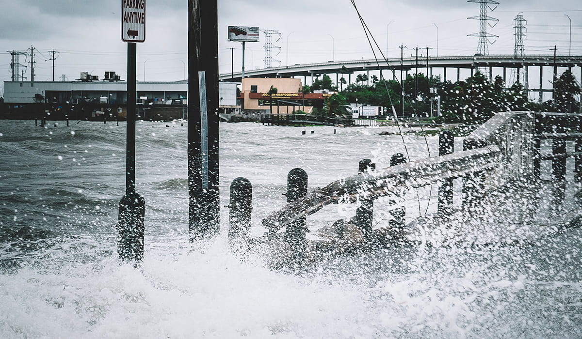
Predicting Texas Storms
When Hurricane Harvey barreled into the Texas coastline in August 2017, it turned roads into rivers and drowned entire towns.
The hurricane stalled for days over Houston and other cities, dumping up to 60 inches of rain in some places, the highest single-storm rainfall ever recorded in the U.S. In all, Harvey caused more than 100 deaths and $125 billion in economic damage.
For many, Harvey was a wake-up call. How could Texas better prepare for major storms?
Nick Fang, a nationally known scientist in flood prediction, is working with the U.S. Army Corps of Engineers to develop better methods to characterize, predict, and cope with massive Texas storms that are growing more unpredictable because of climate change.
He and his team are gathering and analyzing huge sets of Texas rainfall data from the Corps of Engineers, Federal Emergency Management Agency, National Weather Service, National Oceanic and Atmospheric Administration, U.S. Geological Survey, local governments, and regional flood control districts. With this information, they will examine spatial patterns, causes, and trends of these large storms.
“We know that major storms are here to stay,” says Dr. Fang, an associate professor of civil engineering, “but if we can use data to investigate what’s happening in these storms, we can better prepare Texans and save lives and property in the future.”
As part of the project, his team is building an inventory of all recorded storms that lasted longer than six hours, including events with return periods from two years to 1,000 years. Because of Texas’ size and diverse environments, ecologies, and meteorological forces, researchers must determine storm probabilities and causes for a variety of regions. Weather patterns vary widely among West Texas and East Texas, for example, and North and South Texas.
Fang’s work also extends beyond this project. Applying data gathered from the Houston area, he has developed a radar-based flood information and response system for the city of Houston to provide flood risk information for critical infrastructure such as hospitals, nursing homes, fire stations, and wastewater treatment plants.
The system allows for early warnings with real-time visualizations of critical hotspots and inundated areas during storms. It also includes a floodplain map library, a predictive tool that demonstrates inundation levels under various rainfall conditions.
“We want to inform the city’s emergency management operations so they can quickly and accurately conduct emergency closures, evacuations, and rescues,” Fang says. “This system is essentially a decision-making tool that enables leaders to initiate strategies during severe weather events.”
He has also used the same framework to provide flood prevention information at Dallas-Fort Worth International Airport and is helping the state develop the first technical guidance for early-warning systems that can eventually be tailored for individual communities.
Flood early-warning systems have become a critical tool in flood-prone communities because of their ability to monitor rainfall and river levels, provide real-time flood forecasting, and estimate potential damages. They also cost less than infrastructure-related mitigation solutions.
“Data tells us that our storms are growing in intensity,” Fang says. “With these changes comes a need to understand what is happening and why it’s happening, and to develop more precise predictive tools that can help communities address flooding.”
Highlighting Cultural Cartographers
Data analytics has exploded, but its reach has largely neglected the humanities.
Kenton Rambsy, an assistant professor of African American literature, thinks data could be used to bolster our understanding of literature.
“I tell people this work would have only been possible at UTA. Working in a STEM environment offers incredible opportunities to humanities scholars.”
“When it comes to humanities, there’s not a lot of data out there; when it comes to Black humanities, there’s even less,” he says. “We live in an era of automation, and complex datasets can reveal patterns, trends, and associations. Given the recent advancements in data, it’s important to develop research practices that delve into works by Black writers.”
In his new book, The Geographies of African American Short Fiction, Rambsy does just that by examining the geographical references in short stories written by Black authors. The book explores the significance of story setting in racial representation.
He studied 100 anthologies published between 1925 and 2017, focusing on a core group of prolific authors that he calls the Big Seven: James Baldwin, Toni Cade Bambara, Charles Chesnutt, Ralph Ellison, Zora Neale Hurston, Alice Walker, and Richard Wright.
The authors plot characters across multiple locations—for example, the U.S. South. Some authors composed narratives that incorporate Black vernacular speech and feature Southern culture and homegrown characters. Others used the South to visit Black stereotypes at the turn of the 20th century or illuminate racial conflicts. One used it to present the vibrant lives of predominantly African American communities and show how Black people can exist independently of white people and white culture.
A chapter of the book is dedicated specifically to outsiders in the South. In these plots, Black male characters struggle to fit into changing and sometimes troubling environments. Two authors ventured into “rarely chartered territory for major Black authors,” Rambsy writes, by taking on the first-person perspectives of white male characters who witnessed the lynching of Black men.

New York City and Washington, D.C., also emerge as essential locations, from street corners and apartment buildings to movie theaters and a school courtyard. And environments where music predominates often play a particularly integral role in the short stories.
“These settings create abundant possibilities for storytellers to showcase ideas and scenes concerning Black culture, conflicts, crime, and familial memories,” Rambsy writes.
He says this work is largely possible because of the symbiotic relationship between humanities and STEM fields at UT Arlington.
“I tell people this work would have only been possible at UTA. Working in a STEM environment offers incredible opportunities to humanities scholars.”
The book builds on his previous research, which involved developing dataset of 100 of the most prominent novels written by Black authors. He also has taught a class using data analytics to study the work by hip-hop mogul Jay Z, placing the modern star squarely within the tradition of influential Black writers.
Rambsy next plans to grow the body of data on Black literary art to provide a more complete view of both characters and settings and cultural context.
“I come from a family of English majors,” he says. “I followed in their footsteps and fell in love with the idea that you are able to transport yourself to different places without actually ever leaving your house.”
READ MORE

Investigating Earth’s ionosphere-thermosphere
A space physicist at UTA is playing a key role in NASA’s Geospace Dynamics Constellation mission aimed at improving our understanding of the planet’s ionosphere-thermosphere (I-T) system.

Quantifying the benefits of roadside vegetation
Construction management Assistant Professor Kyeong Rok Ryu is helping cultivate a better-looking Texas by creating best practices for roadside vegetation.

Evaluating smart traffic signal design
Civil engineer Pengfei “Taylor” Li hopes to make traffic signals smarter with new simulation techniques and big data.